
Dr. Robert Weller's Cruise, |
|
| The first cruise that the students followed in the school year was Dr. Robert Weller's (WHOI/NOAA) cruise in December 2004 to recover and redeploy a buoy called the Stratus Ocean Reference Station. The ORS Stratus buoy is located at 20° south, 85° west under the stratus clouds west of northern Chili and Peru. | |
| The ORS Stratus is recovered and redeployed every year, usually in October or November, and provides "ongoing climate-quality records of surface meterology, of air-sea fluxes of heat, freshwater, and momentum, and of upper ocean temperature, salinity, and velocity variability. The Stratus Ocean Reference Station is supported by the National Oceanic and Atmospheric Administrations (NOAA) Climate Observation Program". | 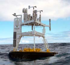 |
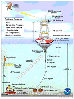
"The ORS Stratus buoys are equipped with two Improved Meteorological systems which provide surface wind speed and direction, air temperature, relative humidity, barometric pressure, incoming shortwave radiation, incoming longwave radiation, precipitation rate, and sea surface temperature." "The IMET data are made available in near real time using satellite telemetry. The mooring line carries instruments to measure ocean salinity, temperature, and currents. On some deployments, additional instrumentation is attached to the mooring to measure rainfall and bio-optical variability. The [NOAA Environmental Technology Laboratory] instrumentation used during the 2003 cruise included a cloud radar, radiosonde balloons, and sensors for mean and turbulent surface meterology." Information, photograph and art are all from Dr. Weller's Stratus Ocean Reference Station Mooring Recovery and Deployment Cruise Report, |
 |